
ABANDONED RAILWAY LINES
Glenbrook & Lapstone
Railway Deviations
Glenbrook and neighbouring Lapstone, in the foothills of the Blue Mountains, have plenty to offer the railway history buff. Within walking distance of each other are a monument to the Chief Engineer for NSW Railways, John Whitton, the father of NSW Railways who first brought the Great Western Line over the Blue Mountains; the picturesque sandstone Lapstone Viaduct over Knapsack Gully; the cuttings of a zig-zag railway; and one of Australia's oldest railway tunnels. All are located close to the Great Western Highway along the path taken by Whitton's first railway over the Blue Mountains. Commenced in 1863, the first section, between Penrith and Weatherboard (now Wentworth Falls), was brought into service on 13th July 1867.
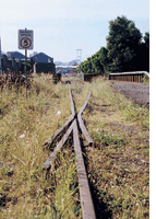
The Lapstone Zig Zag
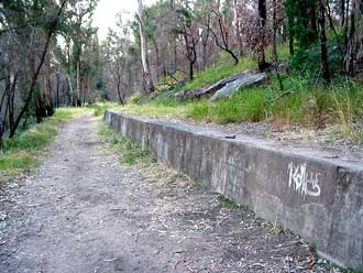
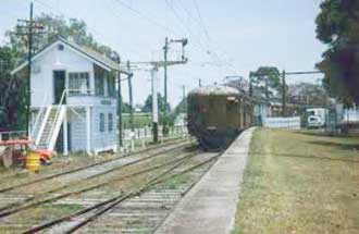
Lucasville station
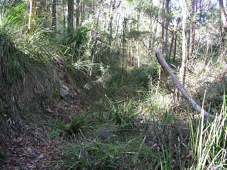
Engineer Whitton wanted to tunnel through the hill but a tight budget meant that a zig zag (or switch-back) was constructed. The cuttings for the zig zag still exist and can be reached by a path at the end of Knapsack Street, Lapstone. The site may be reached by a walking track at the end of Knapsack Street, Lapstone. This takes walkers along Top Road to Top Points past the remains of a railway platform, and thence to Middle Road. Highway upgrading has obliterated the site of Bottom Points, but a set of stairs and a walk along the new highway leads to Knapsack Viaduct.
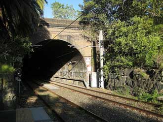
Opened in 1867 it was sometimes known as the Little Zig Zag, being the first and smallest of Whitton's two Zig Zags on the route. The earthworks were carried out by William Watkins, and the track laid by Larkin and Wakeford. The device necessitated reversing the train up or down one of the three legs of the zig zag route. Gradients ranged from a steep 1 in 30 to 1 in 33. The Little Zig Zag remained in use until 1892 when it was bypassed via the Glenbrook tunnel with the same grade but it considerably speeded up travel times. The single track tunnel itself became a bottleneck and was replaced by the Lapstone Gorge Deviation in 1913 with a grade of 1 in 60.
UBD Map 162 Ref B 15
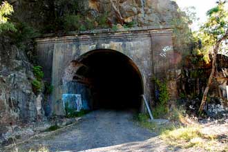
Old Glenbrook Tunnel
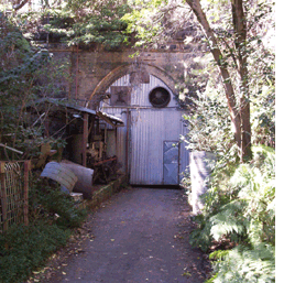 The 660.3m long Old Glenbrook Tunnel was built between April 1891 and December 1892 as part of a deviation which bypassed the Lapstone Zig Zag. To save money, a ventilation shaft was not included as it was believed the current of air passing through it would provide sufficient ventilation. This soon proved to be not the case. The gradient of the S-shaped single-line tunnel was, at 1 in 33, quite steep. Seepage kept the rails wet, leading to slipping and stalling. These shortcomings and the growing need for a second line led to the establishment of a new route through Glenbrook Gorge in 1913 which included a replacement tunnel. The old tunnel was leased for mushroom growing. During World War 2 it was used by the RAAF to store 500 LB. bombs and chemical weapons including mustard gas. The 660.3m long Old Glenbrook Tunnel was built between April 1891 and December 1892 as part of a deviation which bypassed the Lapstone Zig Zag. To save money, a ventilation shaft was not included as it was believed the current of air passing through it would provide sufficient ventilation. This soon proved to be not the case. The gradient of the S-shaped single-line tunnel was, at 1 in 33, quite steep. Seepage kept the rails wet, leading to slipping and stalling. These shortcomings and the growing need for a second line led to the establishment of a new route through Glenbrook Gorge in 1913 which included a replacement tunnel. The old tunnel was leased for mushroom growing. During World War 2 it was used by the RAAF to store 500 LB. bombs and chemical weapons including mustard gas.
The Old Glenbrook Tunnel remains closed and access to the entrances is difficult. The eastern portal can be reached via a walking track which commences at a reservoir alongside where Governors Drive branches off Great Western Highway. The track follows the path taken by the line to a point where the ground is too swampy and the undergrowth too thick to continue. It then leads up the side of the bank and across the top of the portal. The north portal (above) is beside a lane off Barnet Street, Glenbrook.
UBD Map 182 Ref A 1
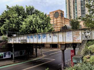
The Knapsack Viaduct
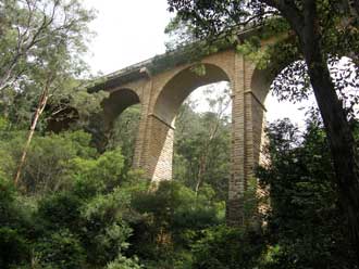
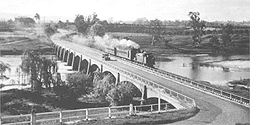
The route adopted by Whitton incorporated an impressive sandstone viaduct over Knapsack Gully. When opened in July 1867, the 5 span viaduct was the largest in Australia, being 104 metres long with the centre arch rising to around 38 metres above the creek bed. The contract for its construction was let to W. Watkins in March 1863 and the work was completed in 1865. It was originally built to carry a single railway track. In 1913 the railway line was diverted to its current path through Glenbrook Gorge and the bridge was abandoned. Downstream is another viaduct across Knapsack Gully which was built in 1913 to take the railway along its new route which it still follows today. This brick viaduct has eight arches.
With the development of the Great Western Road the earlier sandstone viaduct was purchased by the Main Roads Board and incorporated into the Road. It was reopened for two lanes of vehicular traffic on October 23, 1926. In 1938-39 the bridge was carefully widened to ensure that its appearance was not altered. Its use as a road bridge ceased in the 1980s when the highway was diverted to its existing route. A magnificent piece of workmanship, the bridge can now be viewed at close range via a walking track which crosses the bridge along where once ran the railway and later the roadway. For the best view and to appreciate the skills that went into its design and construction, take one of the tracks down into the gully and look up! Walking tracks through the bush in Glenbrook Reserve along the path taken by the railway lead to a memorial to John Whitton and the Lapstone Zig Zag.
UBD Map 162 Ref B 13
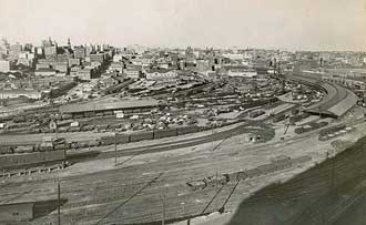
Rozelle-Darling Harbour Goods Line
Balmain Road Junction to Darling Island. Length: 4.1 km. Opened: 23 Jan 1922. Closed: 22 Jan 1996. Lifted
Darling Island to Darling Harbour. Length: 0.7 km. Opened: 22 Jan 1900. Closed: 6 June 1993. Lifted
Darling Harbour to Central Goods Junction Length: 1.7 km. Opened: 6 June 1993. Out of Use.
Jubilee Park Tunnel at the Rozelle end near the light rail station. The tunnel was originally part of the Rozelle - Darling Harbour Goods Line, but is now part of the inner western suburbs light rail link.
The Metropolitan goods line ran from Wardell Rd Junction to Darling Harbour passing through the suburbs of Dulwich Hill, Summer Hill, Lewisham, Haberfield, Leichhardt, Annandale, Glebe, Pyrmont as well as Darling Island, then under Pyrmont Bridge Road at Pyrmont Bridge to enter Darling Harbour and continue through to rejoin the Main lines near Mortuary Station. In its heyday it was the main route for coal, wheat and other goods into and from Rozelle Goods Yard as well.
The Long Cove siding provided entry to and from the Australian Army Ordinance Stores located between the rail line and the Hawthorne Canal. During World War II the line was extremely busy with Troop and Ordinance trains making up the majority of the traffic. Troop trains headed towards Darling Island and the freight being carried was not always on display although aircraft (with wings elsewhere) were often seen on wagons. Tracks of the disused Darling Harbour Goods line behind the ABC Building in Harris Street, Ultimo.
In the 1980s the Goods line from Balmain Rd Signal box to Darling Harbour, which was no longer in regular use, was closed to allow the building of the Sydney Casino. The line lay dormant for a time, used only by the Light rail as far as Wentworth Park. It was reopened as far as Catherine St Lilyfield on 13th August, 2000 for use by the Light Rail Network.
During the 2000s the section between Dulwich Hill and Rozelle also saw a considerable decline in traffic. Rozelle goods yard became overgrown but was used intermittently for the storage of disused railway wagons and passenger cars. Eventually, the sole traffic was a service to deliver cereals to a flour mill at Summer Hill. In 2009 the mill relocated to Maldon in the Southern Highlands and all traffic on the line ceased.
To adequately service the existing handling requirements of the Ports of White Bay and Glebe Island, a new connecting line runs along a corridor on the eastern boundary of the site, next to City West Link Road. In 2010 the NSW Government announced the extension of the light rail from Lillyfield to Dulwich Hill utilising disused lines within the corridor.
UBD Map 12 Ref N 2
Darling Island Goods Yard
 Darling Island was a little known area bounded by Pyrmont Bridge Road, Darling Harbour and Gipps St Pyrmont. Darling Island railway junction is now occupied by the Star Casino. Darling Island was a little known area bounded by Pyrmont Bridge Road, Darling Harbour and Gipps St Pyrmont. Darling Island railway junction is now occupied by the Star Casino.
The area that was Darling Island encompassed all of the wharves as well as a large storage siding area, a wagon repair centre, coal storage sidings for Pyrmont Power Station, mainly used to store wool consignments that could not be accepted into Darling Harbour due to other traffic, and access to the meat sidings at Jones Bay.
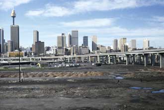
Darling Harbour after the railway goods yard was removed but before redevelopment commenced
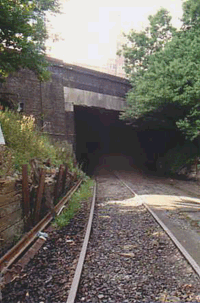
Darling Island goods yard could be accessed from the parcels office and post office that once existed near Central station via a line that still exists. It passes under Broadway and Lee Street via a tunnel (below), emerging in the abandoned railway corridor parallel to Harris Street, Ultimo, behind the ABC building. The monorail travels along this corridor, joining it at the end of Macarthur Street.
 The Darling Island Jctn. signal box appears briefly in the movie, Strictly Ballroom, being used as the home of the parents of the girl who danced with Paul Mecurio. A '49' class Loco appeared briefly in front of the house. The signal box was located where the buses stop at Star City Casino today. Once the light rail leaves the Casino stop and proceeds into the cutting it is travelling on the alignment of the No. 1 siding of the Pyrmont Power House storage sidings. The Darling Island Jctn. signal box appears briefly in the movie, Strictly Ballroom, being used as the home of the parents of the girl who danced with Paul Mecurio. A '49' class Loco appeared briefly in front of the house. The signal box was located where the buses stop at Star City Casino today. Once the light rail leaves the Casino stop and proceeds into the cutting it is travelling on the alignment of the No. 1 siding of the Pyrmont Power House storage sidings.
UBD Map 3 Ref B 8
Ultimo Street railway bridge
Prospect Quarry Branch
Jctn. (Toongabbie) to Prospect Quarry. Length: 5.0 km. Opened: 7 Apr. 1902. Closed: 1945. Lifted.
A privately owned line which ran from Toongabbie in Sydney's west to the Prospect Quarry, roughly following the line of Toongabbie Road. Passengers were conveyed as far as Prospect.
UBD Map 209 Ref C 6
Holsworthy Line
Jctn. (Liverpool) to Anzac Rifle Range. Length: 3.4 km. Opened: 21 Jan 1918. Closed: 21 June 1977. Lifted
Anzac Rifle Range to Holsworthy. Length: .5 km. Opened: 21 Jan 1918. Closed: 21 June 1977. Lifted
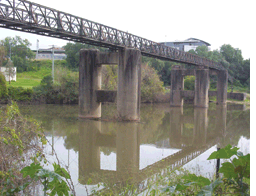 During World War I the Commonwealth Government decided it needed a branch railway to service the army facilities at Holsworthy, which included the Artillery Range, Ordnance (mounted guns and cannon) and Ammunition Stores, the Remount Depot and the Veterinary Depot and Prisoner of War camp. In fact the line was constructed using internee labour. During World War I the Commonwealth Government decided it needed a branch railway to service the army facilities at Holsworthy, which included the Artillery Range, Ordnance (mounted guns and cannon) and Ammunition Stores, the Remount Depot and the Veterinary Depot and Prisoner of War camp. In fact the line was constructed using internee labour.
It branched off the Macarthur Line before Liverpool station, crossing the Georges River via a bridge, the pylons of which remain today. The bridge had eight x 30 metre approach spans, four on each side which came from the old crossing of the Wollondilly River near Carrick and Solitary Creek near Tarana; while the main span was an eight foot truss from the old single-line bridge over Argyle Street, Moss Vale. After crossing the river the line followed Greenhills Avenue through Clinches Pond Reserve, then curved to the east, following Anzac Parade on its south side past the Anzac Rifle Range.
After the line was opened, several additional sidings were constructed. The first was the Ordnance Stores Siding, opened 29 April 1919, with standing room for 75 four-wheel vehicles on three loop sidings. On 3rd February 1930, the Commonwealth suspended services on the line beyond the Rifle Range and from that date only carried out repairs on the section of line between Liverpool and the Range. The last train ran on the line on 25th June, 1960.
 Besides the aforementioned bridge piers, there are a number of relics remaining. These include the solid bridge on Harris Creek (now modified as a foot bridge), substantial ruins of the platform at Holsworthy and a few ridge lines suggesting the original tracks, eg. at Clinches Pond Reserve (above). At the Harris Creek bridge (now a footbridge alongside the road bridge) there is a carved plaque with the words "Erected 1917" with kangaroo and emu carvings on each side and surmounted by a crown and the interleaved initials "GCC" (German Concentration Camp), identifying its builders. Traces of the line also show up on aerial maps, especially of the branches and sidings to the Moorebank Depot. Besides the aforementioned bridge piers, there are a number of relics remaining. These include the solid bridge on Harris Creek (now modified as a foot bridge), substantial ruins of the platform at Holsworthy and a few ridge lines suggesting the original tracks, eg. at Clinches Pond Reserve (above). At the Harris Creek bridge (now a footbridge alongside the road bridge) there is a carved plaque with the words "Erected 1917" with kangaroo and emu carvings on each side and surmounted by a crown and the interleaved initials "GCC" (German Concentration Camp), identifying its builders. Traces of the line also show up on aerial maps, especially of the branches and sidings to the Moorebank Depot.
UBD Map 269 Ref H 8
Royal National Park Branch
Jctn. (Loftus) to The Royal National Park. Length: 1.9 km. Opened: 9 Mar 1886. Closed: 11 June 1991. A section was re-opened as tourist tram line: 1 May 1993.
 Built specifically for us by the Military, the line linked the station of Loftus on the Illawarra Line to an Army Camp in Royal National Park. The line opened shortly after the main line and at various times served the army camp, park visitors and residents of nearby Grays Point. At its peak, 25 services were provided on weekends. When electric trains were introduced in 1926, this branch was included in the electrification. Built specifically for us by the Military, the line linked the station of Loftus on the Illawarra Line to an Army Camp in Royal National Park. The line opened shortly after the main line and at various times served the army camp, park visitors and residents of nearby Grays Point. At its peak, 25 services were provided on weekends. When electric trains were introduced in 1926, this branch was included in the electrification.
The Scouts Platform was introduced in 1946 to serve the nearby NSW Scouts Jamboree of that year. The original terminus station boasted a 10-car island platform, goods bank and five sidings. Services were reduced in the 1960s and 1980s, and by the mid 1980s only two trains a week serviced the line. Following the 1990 Cowan Bank collision, it was used to test whether automatic sanders could insulate a train's wheels from the track circuit (they could). It was also used for driver training; track irregularities from wheel skids are still visible is places.
In 1978, the Royal National Park station was closed to make way for an improved national park visitors centre. A new station was constructed adjacent to the site, and opened in time for the park's centenary the following year. In 1991, a signalling problem caused the suspension of services. When it was found that $400,000 would be required to bring the line up to an acceptable standard, it was officially closed. At the time, patronage was an average of three people per train. Two years later the line was taken over by the Loftus-based Sydney Tramway Museum, which now uses it to run tourist trams. UBD Map 332 Ref J 15
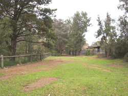
Boronia Relief Line
Boronia Tunnel No. 5
Around the turn of the 20th century, the Railways Dept. found that the long haul up Cowan Bank between Hornsby and the Hawkesbury River was causing delays for passenger trains being slowed down by fully laden freight trains. Their solution was to build a relief line.
Boronia Tunnel No. 5 was constructed as part of this line. Being on the hill side of the main line, it was a tighter curve than the main line and had a 1 in 40 grade, which is close to the maximum grade a steam train can negotiate. As a result, trains encountered great difficulty using the line. Many fully laden trains would grind to a halt on the climb and find it impossible to get started again. Within a year the line had to be abandoned. To relieve the situation, the line was duplicated in 1909.
|
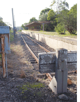
Ropes Creek Line
St Marys to Dunheved. Length: 2.8 km. Opened: 1 Mar 1942. Closed: 22 Mar 1986. Out of use
Dunheved - Ropes Creek. Length: 3.0 km. Opened; 29 June 1942. Closed; 22 Mar 1986. Out of use

Ropes Creek station
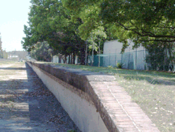
The Ropes Creek line was built during World war II to serve the Department of Defence area to the north of St Marys station. It had three stations on it: Dunheved, Cochrane and Ropes Creek. The latter two are on restricted property, so the opportunities to visit are limited. Currently, the first kilometre is used as a storage siding. Though out of use, sections of the rest of the track remain in place as far as and alongside Forrester Road to where it crosses Ropes Creek, Dunheved. The station platform of Dunheved (above), whilst overgrown, remains intact.
UBD Map 165 Ref F 6
Widemere Quarry Line
Fairfield to Widemere Quarry, Prospect Hill. Length: 8.3 km. Opened October 1925; closed 2nd June, 1945.
A 61 cm (2 feet) gauge privately owned branch line to a quarry operated by the Sydney and Suburban Blue Metal Co. running from the Main Southern Line at Fairfield to the company's quarry on the southern side of Prospect Hill. The tracks commenced at the Fairfield station goods yard and followed a route alongside public streets including Court Road, The Horsley Drive to Smithfield, then alongside Dublin, Cordeaux and Hassall Streets and Widemere Road, crossing Prospect Creek over a timber-framed trestle viaduct. The trains running down the main street of Smithfield were a feature of the town's daily life.
UBD Map 208 Ref Q 12
Rogans Hill branch line
Westmead Junction to Castle Hill
Length: 1.4 km. Opened: August 1904 (tram), 10.7 km extension: 28 Jan 1923 (train). Closed: 31 Jan 1932. Lifted.
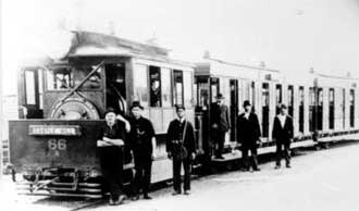
A steam tram at the Castle Hill terminus
The Rogans Hill line had its origins as a steam tramway which extended from Parramatta north to Castle Hill. This tramway broadly ran alongside Church Street, Windsor Road and the Old Northern Road. The railway, which extended the service, followed most of this route, except that it branched from the Main West line at Westmead and joined the original route at Northmead. It also extended north of Castle Hill to Rogans Hill.
The line was never very successful, and suffered from competition with road traffic. Because it followed the road alignment, nearly all traces of the line have been obliterated in subsequent road widenings. One remnant is a concrete pier on the bed of Toongabbie Creek upstream (westwards) of the bridge carrying Redbank Road over the creek. In 1923 when the tramway was converted into a railway, a new loop was constructed running from Westmead which crossed Toongabbie Creek. The tramway pier is from this loop.
UBD Map 191 Ref C 13
Rookwood Cemetery Line
Jctn. (Rookwood Line) to No 1 Mortuary Station. Length: 1.1 km. Opened: 22 Oct 1864. Closed: 29 Dec 1948. Lifted
No 1 Mortuary Station to No 3 Mortuary Station. Length: 1.3 km. Opened: 26 May 1897. Closed: 29 Dec 1948. Lifted
No 3 Mortuary Station to No 4 Mortuary Station. Length: 1.0 km. Opened: 19 Jun 1908. Closed: 29 Dec 1948. Lifted
 Rookwood Cemetery was created in the early 1860s as a replacement for Sydney's Sandhills Cemetery which was removed so that Central Station could be built. The branch line to Rookwood Cemetery opened as the Necropolis line on 22nd October 1864. Trains to the cemetery, which ran exclusively for funerals, left from the Mortuary Station near Central Station in Sydney. Rookwood Cemetery was created in the early 1860s as a replacement for Sydney's Sandhills Cemetery which was removed so that Central Station could be built. The branch line to Rookwood Cemetery opened as the Necropolis line on 22nd October 1864. Trains to the cemetery, which ran exclusively for funerals, left from the Mortuary Station near Central Station in Sydney.
The single station on the branch line when it opened was called Haslem's Creek Cemetery. Its name was changed to Necropolis prior to 1872 and changed again to Mortuary General Cemetery on 16th July 1897. It was then changed to Cemetery Station No 1 15th June 1908 when the Roman Catholic Platform, which had been opened on 31st December 1901, had its name changed to Cemetery Station No 2. Mortuary Station No 3, which opened on 26th May 1897, became known as Mortuary Terminus two months later. Its name was changed to Cemetery Station No. 3 in June 1908 to create uniformity between the station names within the cemetery.
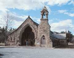
The line's name was changed to the Rookwood branch line on 1st January 1914. No trace remains of it today except for the points and a short section of track that led to the cemetery line beyond Lidcombe station. The No. 1 Mortuary Station was constructed in 1864 and remained in use as the main station until the line's closure in December 1948. It was used as a chapel until 1958 when a fire gutted its interior. The Gothic-style building was then dismantled and re-erected stone by stone in Canberra as All Saints Anglican Church in the parish of Ainslie (above). The Redfern Mortuary Terminal, Regent Street, Redfern, from which trains left the city on their journey to Rookwood, was opened in 1869 and closed simultaneously with No 1 Mortuary Station at Rookwood Cemetery. St Paul's Anglican Church (which is today The Greek Orthodox Church), 242 Cleveland Street, Redfern, was the church where Anglican funeral services were held prior to the departure of funeral trains from the nearby Mortuary Station.
More information
Warwick Farm Racecourse Branch
Jctn. (Warwick Farm) to Warwick Farm Racecourse. Length; 1.6 km. Opened: 2 Jun 1889. Closed: 19 Nov. 197. Re-opened: 17 Feb. 1979, Closed: 7 Dec 1991. Current statues: lifted.
Above: a red rattler pulls into Warwick Farm Racecourse station. Below right: The abandoned platform today
 The Warwick Farm Racecourse branch was a 1.6 km line from Warwick Farm to the nearby racecourse, owned by the Australian Jockey Club. The branch left the Main South line near Warwick Farm station. It then crossed Hume Highway at a level crossing before ending at the Racecourse station alongside Governor Macquarie Drive. The line had a 200m Horse Dock platform, and facilities for storing up to 8 trains. The Branch was closed in 1991. The platform as well as the gates on the racecourse boundary near where it crossed Hume Highway are all that remain of the line today. The Warwick Farm Racecourse branch was a 1.6 km line from Warwick Farm to the nearby racecourse, owned by the Australian Jockey Club. The branch left the Main South line near Warwick Farm station. It then crossed Hume Highway at a level crossing before ending at the Racecourse station alongside Governor Macquarie Drive. The line had a 200m Horse Dock platform, and facilities for storing up to 8 trains. The Branch was closed in 1991. The platform as well as the gates on the racecourse boundary near where it crossed Hume Highway are all that remain of the line today.
UBD Map 249 Ref L 15
Old Oatley Station and Line Deviation
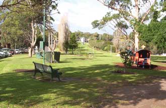
If you've ever shopped in the southern suburb of Oatley and thought that the town planners left room for a railway station between Oatley Parade and Oatley Avenue, you would be right. Oatley station once did exist there but it had to be moved. Soon after the opening of the Illawarra railway line in 1885, train drivers found that the grade up the hill from the original Como Bridge to Mortdale was too steep for fully loaded coal trains. A deviation was built around the centre of Oatley in 1905 to reduce the grade for Sydney bound trains to a maximum of 1 in 80. The new line deviates to the west of the original line through a cutting. Oatley station was moved from its original position to it present location. The route taken by the original line is still clearly visible at the Oatley end of the bridge. The walking path to the bridge follows the path of the original line. From the beginning of the houses the line continued north, occupying the narrow strip of land between Oatley Parade and Oatley Avenue. It crossed Hurstville Road near the roundabout and proceeded over the rise to Mortdale station. The two platforms of the original Oatley station are now buried under James Oatley Memorial Park (left).
UBD Map 293 Ref C 12
Richmond - Kurrajong Line
Richmond to Kurrajong. Length: 13.4 km. Opened: 8th November, 1926. Closed: 26th July, 1952. Lifted
The extension of the railway line from Richmond to Kurrajong was intended to open for development that part of Sydney west of the Hawkesbury River. Agitation for the extension began as earlier as 1883 but by the time it happened it was a few decades too late as transportation by road of the area's citrus fruit crop to Sydney was already firmly established.
The service did bring a fresh impetus to the development of the area and introduced a new source of income for a number of local families. Several of the larger homes in the area were converted into guest houses and were building up a good reputation when the depression hit and handicapped development for a number of years. The Nepean Sand and Gravel Company operated a quarry at Yarramundi Falls from April 1925, with sand for the construction of the Sydney Harbour Bridge being carried by rail over a section of the still uncompleted Kurrajong railway. The company continued to use the line and its siding until 1945, after which time the service slid into unprofitability.
Heavy rain in June and July 1952 caused land subsidence in cuttings near Kurrajong which resulted in land slips and buckled tracks. This and the unprofitability of the service led to it being officially closed on 26th July, 1952 though flooding of the Hawkesbury River had prohibited its use for a few weeks. The decision to discontinue the railway service sparked a storm of protest in the district. Locals claimed rather optimistically that the slip which blocked the line could be removed by bulldozers in a matter of hours but the Government stood by its decision. Attempts are presently afoot to re-establish the line as a tourist railway. Much of the formation from North Richmond to Kurrajong still exists and still passes through farmlands. A substantial bridge which took the line over Redbank Creek remains in good order and historic features such as the Kemsley platform and the Kurrajong goods shed still exist (although the latter is now located in the Pioneer Village at Wilberforce). Kurrajong even has a town square - Pansy Junction - named after the steam engines that worked the line.
Bondi, Murriverie Road
The line of road was originally laid out in 1890 as a tramline by Francis O'Brien, of the Homestead, Bondi, to service his quarry at Murriverie Rocks. The tramline was later used for the same purpose by former convict James Underwood (1771 - 1844) of Paddington who established Sydney's first private shipyard on the Tank Stream, and an early distillery on his 100 acres at Paddington. It is possible that some remains of the tramline might be still under the road.
Thornleigh Zig-Zag Railway
Overgrown formation of the Thornleigh quarry railway line
The Lithgow Zig-Zag in the Blue Mountains is the most well known of the three such railway lines built in the Sydney region. The other two are at Lapstone and Thornleigh. The Thornleigh Zig-Zag, built in 1883-4 by Messrs. Amos & Co., was used to haul crushed sandstone from a quarry on Hall's Creek behind Oakleigh Oval 30 metres up a steep gradient to the main line at Thornleigh station. There were two reversing stations. The crushed sandstone was used as ballast for railway sleepers on the Northern railway line (Strathfield to Hornsby) which was being built at that time. The branch was closed before 1900. Evidence of the line are still visible, including a cutting near Thornleigh station and embankments in the bush near Tillock Street (right).
UBD Map 152 Ref M 11.
Camden Branch
Campbelltown to Camden. Length: 12.8 km. Opened: 10 Mar 1882. Closed: 1 Jan 1963. Lifted
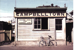
The Camden line extended from Campbelltown to Camden and was built to move agricultural produce from farms in the Camden area to Sydney. However for much of its lifetime its most important cargo was coal from nearby coalfields. When an alternate loader was constructed at Glenlee, the line was closed.
The line branched off the main Macarthur line after it crossed Fishers Creek. It followed the northern side of Narellan Road (then called Camden Road), then Camden Valley Way (then called Hume Highway and Gt. Southern Road) terminating in Camden between Elizabeth and Edward Streets. Access was via Station Street. A notable feature of the line was the very steep Kenny Hill (1 in 19 grade) which was climbed after crossing Bow Bowing Creek. Long trains often failed to make it to the top the first time, and had to either back up and try again, or divide the train.
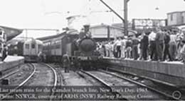
Last steam train for the Camden branch line, New Year's Day, 1963. Photo: NSWGR, courtesy of ARHS (NSW) Railway Resource
Special trains would run to Maryfields station each Good Friday, so people could attend the Via Crucis ceremony at the nearby Franciscan Brothers Monastery. Other stations were at Narellan (at the end of Sharman Close), Graham's Hill (cnr. Graham Hill Road), Kirkham (cnr. Kirkham Lane) and Elderslie (opposite Macarthur Road). There were also stations at Kenny Hill and Currans Hill alongside Narellan Road that were operational until the 1940s. Apart from the Kenny Hill cutting and some of the formations near where the Maryfields and Kirkham stations once stood, all evidence of the line has been buried beneath widened roads and buildings.
UBD Map 346 Ref A 3
Potts Hill Branch
Jctn. (Regents Park) to Potts Hill Pumping Station. Length: 1.0 km. Opened: 11 Nov. 1912. Closed: 27 Apr. 1966. Lifted
No 2 Reservoir Construction Line to No 2 Reservoir. Length: 0.8 km. Opened: 1916. Closed: 27 Apr. 1966. Lifted
This was a short, fairly obscure branch serving the pumping station at the Potts Hill Reservoirs. The line left the Lidcombe - Cabramatta line just to the north of Regents Park station. It then headed south, crossing Amy St before turning south east to follow the water supply channel. It then crossed over the goods line before terminating at a loop at the pumping station. The line was owned by the Metropolitan Water Sewerage and Drainage Board, and carried NSWGR passenger trains.
UBD Map 251 Ref M 2
Woronora Cemetery Line
Jctn. (Sutherland) to Woronora Cemetery. Length: 0.7 km. Opened: 30 June 1900. Closed: 24 May 1947. Lifted
The Woronora Cemetery branch was a short line extending from the main line just south of Sutherland Station. It crossed over East Parade near the junction of Linden Street, and continued curving around to the north west, ending at the station. With the rise of the motor car, funeral trains declined and the service was eventually suspended. The line was never electrified, and in its final years the service was provided by a CPH rail motor.
UBD Map 332 Ref H 4
|

.gif)
.gif)