Dedication
To John Oxley Parker, ESQ., of Chelmsford, Essex.
London, February 10, 1823.
Dear Sir — Feelings of gratitude for your kind attention to me in the early part of life, have induced me to dedicate to you the following short Journal of my passage over the Blue Mountains, in the colony of New South Wales, under the persuasion that it will afford you pleasure at all times to hear that any of your family have been instrumental in promoting the prosperity of any country in which they may reside, however distant that country may be from the immediate seat of our Government.
Since my return to England many of my friends have expressed a wish to peruse my Journal. To meet their request in the only practicable or satisfactory manner, I have consented to its being printed. Devoid as it is of any higher pretensions than belong to it as a plain unvarnished statement, it may not be deemed wholly uninteresting, when it is is considered what important alterations the result of the expedition has produced in the immediate interests and prosperity of the colony. This appears in nothing more decidedly than the unlimited pasturage already afforded to the very fine flocks of merino sheep, as well as the extensive field opened for the exertions of the present, as well as future generations. It has changed the aspect of the colony, from a confined insulated tract of land, to a rich and extensive continent. 1
This expedition, which has proved so completely successful, resulted from two previous attempts. One of these was made by water, by His Excellency the Governor, in person, whom I accompanied. We ascended the River Hawkesbury, or Nepean, from above Emu Island, to the mouth of the Warragomby 2, or Great Western River, where it emerges from the mountains, and joins itself to that river, from its mouth. We proceeded as far as it was navigable by a small boat, which is only a few miles further. It was found to lose itself at different places, almost entirely underneath and between immense blocks of stones, being confined on each side by perpendicular cliffs of the same kind of stone, which sometimes rose as high as the tops of the mountains, through which it appears to have forced, or worn its way, with the assistance, probably, of an earthquake, or some other great convulsion of nature.
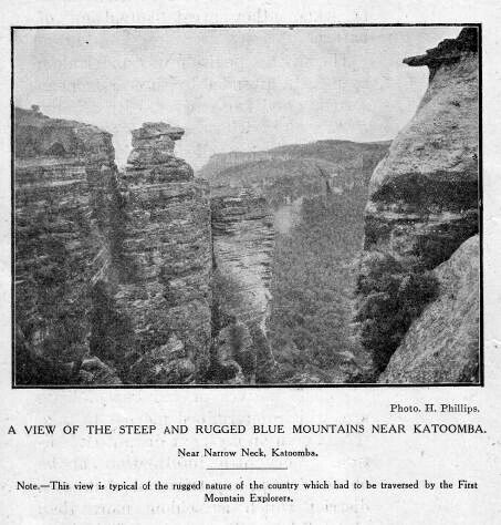
A view of the steep and rugged Blue Mountains near Katoomba (photograph)
The other expedition was undertaken by myself, attended by three European servants and two natives, with a horse to carry provisions and other necessaries. We travelled on the left, or south bank of the western river, and found no impediment, by keeping in the cow pastures, and crossing the different streams of water before they enter the rocks and precipices close to the river. We were unable, however, to penetrate westward, finding ourselves turned eastward towards the coast. We returned sooner than I intended, owing to one man being taken ill. The natives proved but of little use, which determined me not to take them again on my more distant expedition, Very little information can be obtained from any tribe out of their own district, which is seldom more than about thirty miles square. This journey confirmed me in the opinion, that it was practicable to find a passage over the mountains, and I resolved at some future period to attempt it, by endeavouring to cross the river, and reach the high land on its northern bank by the ridge which appeared to run westward, between the Warragomby and the River Grose. I concluded, that if no more difficulties were found in travelling than had been experienced on the other side, we must be able to advance westward towards the interior of the country, and have a fair chance of passing the mountains. On inquiry, I found a person who had been accustomed to hunt the kangaroo in the mountains, in the direction I wished to go; who undertook to take the horses to the top of the first ridge. Soon after I mentioned the circumstance to His Excellency the Governor, who thought it reasonable, and expressed a wish that I should make the attempt. 3 Having made every requisite preparation, I applied to the two gentlemen who accompanied me, to join in the expedition, and was fortunate in obtaining their consent. Before we set out, we laid down the plan to be pursued, and the course to be attempted, namely, to ascend the ridge before-mentioned, taking the streams of water on the left, which appeared to empty themselves into the Warragomby, as our guide; being careful not to cross any of them, but to go round their sources, so as to be certain of keeping between them and the streams that emptied themselves into the River Grose.
To these gentlemen I have to express my thanks for their company, and to acknowledge that without their assistance I should have had but little chance of success.
The road which has since been made deviates but a few rods in some places from the line cleared of the small trees and bushes and marked by us. 4 Nor does it appear likely that any other line of road will ever be discovered than at the difficult and narrow passes that we were fortunate to discover; by improving which, a good carriage road has now been made across the mountains. Mount York is the western summit of the mountains; the Vale Clwyd the first valley at their foot; from which a mountain (afterwards named Mount Blaxland by His Excellency Governor Macquarie) is about eight miles, which terminated our journey.
I remain, dear Sir, most respectfully,
Your affectionate Nephew,
GREGORY BLAXLAND.
1. Blaxland did not exaggerate when he referred to the “important alterations” resulting from his expedition, and he cleverly sums up the matter in his reference to the “changing of the aspect of the colony” into a “rich and extensive continent.”
2. This river is now known as the Warragamba
3. This is proof positive that Blaxland originated the expedition, and became the leader, Wentworth and Lawson being associated with him. The ages of the explorers at this time were: Blaxland 35, Wentworth 19, Lawson 38. The plan devised was destined to prove successful, and originated with Blaxland. He had evidently pondered the matter, after his two previous abortive attempts, and had taken careful notes of the general appearance of this portion of the country.
4. This is interesting, as it shows that Cox’s road followed very closely on Blaxland’s tracks, with the single exception of the ascent of the first range. (This in reference to the road made by William Cox under Governor Macquarie’s direction.) “Mount Blaxland”— This has been identified as that isolated sugar-loaf on the right bank of the Cox River, distant about 7 miles S.W. from Mount York. The mountain is very little changed at the present day (1913), and no doubt presented much the same appearance to Blaxland. Blaxland is hardly correct in ascribing the naming of this mountain to Governor Macquarie. The name was bestowed upon it by G. W. Evans, subsequently confirmed by Governor Macquarie, on arrival at the terminal point of Blaxland’s expedition, which was at Mount Blaxland. Two other smaller conical shaped hills on the opposite sides of the stream were named Wentworth and Lawson’s Sugar-Loaves respectively, by Evans.