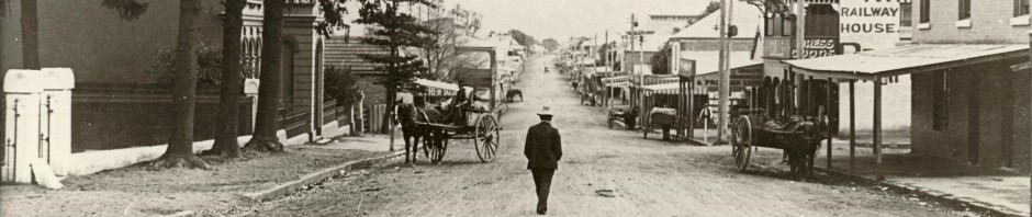
Castlereagh, New South Wales, Australia is located east of the Nepean River north of Penrith. This suburb is one of the most historic sites in Australia’s history, being one of Governor Lachlan Macquarie’s five towns founded in 1810. After two hundred years, the rich river flats continue to provide for a thriving agricultural industry along the Nepean River. Many of this district’s pioneering families originated from Castlereagh. The suburb’s historical importance is reflected in its many surviving farmhouses, outbuildings, churches and cemeteries. Castlereagh Road is an important transport link connecting the Hawkesbury and Penrith regions. The impact of the massive Penrith Lakes Scheme has, and will in the future, change the face of Castlereagh and its neighbouring suburbs.
33 40’00″S 150 41’00″E
| Postcode: 2749 | Distance from Sydney: 67 km |
| Area: 32.23 km2 or 3223 hectares | Castlereagh NSW on Google Maps |
| Federal Government: Castlereagh is located in the Federal Government Electorate of Lindsay. |
| Aboriginal Districts: Castlereagh is located in the Deerubbin Local Aboriginal Land Council Area. |
Halls
-
Castlereagh Hall: Castlereagh Road, Castlereagh NSW 2749.
Ph: (02) 4777 4179.
Schools
-
Castlereagh Public School: Post Office Rd, Castlereagh 2749.
Ph: (02) 4776 1197. -
The Lakes Christian College (formerly known as Kindalin Christian School): 206 East Wilchard Road, Castlereagh, 2749.
Ph: (02) 4777 4057.
Landscape Profile
Castlereagh Woodlands
The Castlereagh Woodlands are found on the Tertiary alluvial deposits and include Ironbark Forest, Scribbly Gum Woodland and Swamp Woodland, each growing in slightly different conditions. Ironbark forest with Broad-leaved Ironbark, Eucalyptus fibrosa is found on deep, well-drained reddish clay soils; examples can be seen around Castlereagh. Eucalyptus fibrosa is the dominant tree species, generally forming pure stands, but it may also be associated with Mugga Ironbark, Eucalyptus sideroxylon and Narrow – leaved Ironbark, Eucalyptus crebra. A small tree layer of Melaleuca decora and an understorey of sclerophyllous shrubs to 2 m high is generally conspicuous. No particular species predominates in the understorey, although the pea family Fabaceae is well represented. Shrub species which may be locally abundant are Dillwynia tenuifolia, Dodonaea falcata, Hakea sericea, Melaleuca nodosa, Mirbelia rubiifolia and Pultenaea villosa. A number of species and forms are endemic to the Castlereagh Woodlands.
Scribbly Gum Woodland is found on sandy soils of the Tertiary alluvium, in the Castlereagh-Londonderry area and at Holsworthy. Eucalyptus sclerophylla and Angophora bakeri are the most common species. Other tree species that may be present are Eucalyptus fibrosa, Eucalyptus eugenioides, and very rarely, Eucalyptus gummifera. The understorey; consists of sclerophyllous shrubs which may form a continuous cover or be more open, with grasses in between. Common shrub species are Banksia spinulosa, Grevillea mucronulata, Hakea sericea, Leptospermum trinervium and Melaleuca nodosa. Swamp Woodland with Eucalyptus parramattensis, Eucalyptus sideroxylon and Melaleuca decora is found in poorly drained situations. Open-forest of Eucalyptusfibrosa is found with Grey Box, Eucalyptus moluccana, on the transitional zone between Wianamatta Shale and Tertiary alluvium. A mixture of species is found on these two soil types. Eucalyptus fibrosa, one of the most common species on the Tertiary alluvium and Eucalyptus moluccana, a common species on Wianamatta Shale, dominate. Other tree species present include Eucalyptus eugenioides and Eucalyptus sclerophylla. The understorey is dominated by low shrubs with a mixture of the hardier species from the Wianamatta Shale and Tertiary alluvium. Bursaria spinosa, Daviesia ulicifolia, Dillwynia juniperina, Hardenbergia violacea, Exocarpus cupressiformis, Melaleuca nodosa and Acacia parramattensis are the most common species. Small trees of Melaleuca decora are often conspicuous.
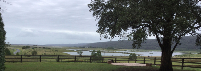
Penrith Lakes
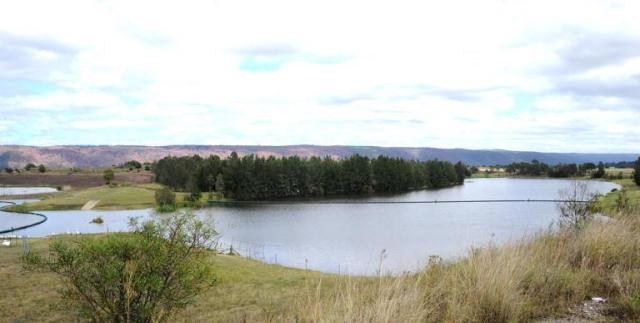
- Total area – 1,935 ha
-
Water source – Nepean River
-
Urban Land – 250 ha
-
Recreation Land – 1000 ha
-
Water Area – 750 ha
-
The total lineal extent of lake foreshore will be about 40 km – and the frontage to the Nepean River about 11 km. The area 3 km north of Penrith, known now as the Penrith Lakes Scheme and operated by a conglomerate of companies that combined their landholdings and quarrying operations in 1979 (i.e. Boral, CSR, and Pioneer International), is by far the largest extraction site in the area. This site supplies around 75% (140 tonnes of sand and gravel) of Sydney’s sand and crushed aggregate requirements, including about 85% of the materials for ready mixed concrete.
-
Penrith Lakes Development Corporation (PLDC) administered the lakes and mining operations. It was formed when three quarry companies joined together in 1980 to form the Corporation. At the time PLDC was formed, the Castlereagh quarry site produced most of the sand and gravel for the greater Sydney construction market.
PLDC is also responsible in the rehabilitation of the site by constructing parkland and a system of lakes which will serve both as flood mitigation and outdoor recreational playground and residential development areas. The transformation of the site is well under way
PLDC states it is ‘committed to the site for many years to come, to oversee the completion of the original Penrith Lakes Scheme vision – creating a natural and environmental wonderland of lakes, parkland and native bush as a setting for some of Sydney’s most desirable home sites’.
Historical profile
Origin of the place name – Castlereagh
This suburb takes its name from the Irish peer, Lord Viscount Castlereagh (1769-1822), who was responsible for the Act of Union between Ireland and England in 1803. Governor Lachlan Macquarie named the area in December 1810 during a tour of the Hawkesbury-Nepean region not long after his arrival in the Colony of New South Wales. Macquarie chose Castlereagh as one of his five towns, the others being Windsor, Richmond, Wilberforce, and Pitt Town. Castlereagh was designed to provide storage space and accommodation for the local community, especially during flood time. In his journal on 6 December 1810 Macquarie wrote ‘The township for the Evan or Nepean District I have named Castlereagh in honor of Lord Viscount Castlereagh’. A sign bearing the name Castlereagh was erected in 1811 after the streets and a town square had been marked out by the surveyor James Meehan.
Circumstances however, ensured that Penrith, not Castlereagh, became the focal point of the area and this site was never developed. The present township is located five kilometres away from Macquarie’s original site.
Historical Timeline
| 1799 | A major flood of the Nepean River | |
| 1803 | 1 July | Mary Collett received a land grant at ‘Birds Eye Corner’. |
| 1804 | 4 June | John Lees received land grant at Castlereagh. Later he gave part of this grant for a Methodist Church to be erected. |
| 1804 | 11 August | James McCarthy received land grant which he later named Crane Brook Farm. |
| 1806 | A major flood of the Nepean River | |
| 1809 | A major flood of the Nepean River | |
| 1810 | 6 December | Governor Lachlan Macquarie named Castlereagh as one of his five towns |
| 1811 | Surveyor James Meehan marked out the streets and square | |
| 1811 | A major flood of the Nepean River | |
| 1814 | 28 April | A glebe house and school completed for Rev. Henry Fulton in Church Street |
| 1814 | 11 July | Rev. Henry Fulton’s school opened. Called the Classical Academy for Young Gentlemen, this school was the first secondary school in Australia. |
| 1814 | First burial in Castlereagh Anglican cemetery | |
| 1817 | 7 October | The first Methodist chapel in the southern hemisphere was opened, erected by John Lees |
| 1818 | 4 January | James Tobias ‘Toby’ Ryan born at Castlereagh |
| 1822 | John Single built ‘Nepean Park’ | |
| 1825 | Rev. Henry Fulton’s school was closed | |
| 1826 | 22 February | Joseph Daniel Single born |
| 1836 | 4 August | Ann Fulton, wife of Henry Fulton died |
| 1836 | John Lees died at Castlereagh | |
| 1840 | 17 November | Rev. Henry Fulton died and is buried at Castlereagh Cemetery on the 19th Nov. |
| 1848 | Methodist Chapel opened – the second on the site | |
| 1858 | 1 May | Castlereagh School opened. It closed in 1935. |
| 1878 | 11 December | Christchurch Anglican Church was consecrated. This church replaced Fulton’s church in Church Street which had been destroyed by fire. |
| 1878 | 28 January | John Single of ‘Nepean Park’ estate died. |
| 1879 | 3 March | Upper Castlereagh School opened. It closed in 1975. |
| 1895 | 9 September | Municipality of Castlereagh proclaimed. |
| 1911 | 26 September | William Hart flew over Castlereagh and up the river to Edinglassie, the first aeroplane flight in the district. |
| 1923 | First cotton grown in Australia at Castlereagh by G. A. Bond & Co. on the corner of Church Lane and Castlereagh Road. | |
| 1935 | 17 December | Castlereagh School closed. |
| 1948 | 12 August | Announced that Castlereagh Council would amalgamate with Penrith not Windsor and Richmond as previously recommended. |
| 1948 | December | Elections held for the new Council. |
| 1949 |
1 January |
Castlereagh, Mulgoa, St. Marys and Penrith Shires amalgamated to form the Municipality of Penrith. |
| 1957 | The present Castlereagh School erected. | |
| 1980 | Penrith Lakes Scheme established. | |
| 1995 | June | Development Application (DA3) to quarry 403 ha was approved. |
Historic buildings & places
|
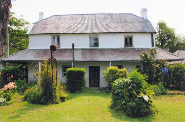
Hadley Park Home of the family of Charles Hadley. The house was built c. 1812 and the property remained in the ownership of the Hadley family until 1970. The Hadley family were among the first settlers at Castlereagh farming along the Nepean River.
|
 |
|
Nepean Park Home of the family of John Single. John Single acquired Nepean Park in 1819 and the house was built 1822. John Single was one of the most successful pioneers in the Nepean district. He made full use of new scientific methods in agriculture and grazing. He built a school on his property and supported the building of the Castlereagh Anglican Church. |
 |
|
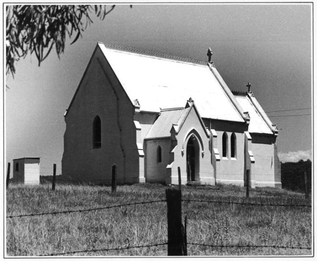
Christ Church Anglican Church The first Anglican Church was built in 1813 within the surveyed town of Castlereagh. This church was destroyed by fire in the early 1870s. Christchurch was consecrated in 1878 and is located in Church Lane overlooking the fertile river flats. |
 |
|
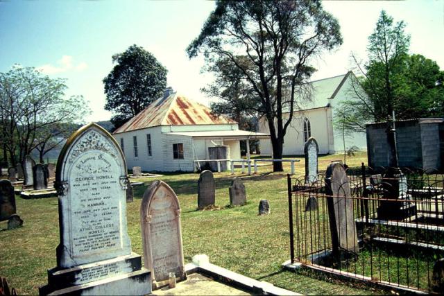
Upper Castlereagh Methodist Church & Cemetery The land on which the first Wesleyan Church built in Australia stands was part of a grant to John Lees in 1804. In 1817, the small chapel was opened. In 1848, the Church was replaced by the present stuccoed building. The cemetery was opened in 1836. |
 |
|
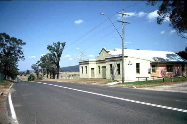
Castlereagh Hall The Municipality of Castlereagh was proclaimed in 1895. This building was built as part of the Council’s depression relief during the early 1930s. The municipality was amalgamated with Penrith Council in 1949. |
 |
Bibliography
For more information on Castlereagh:
-
Search Penrith City Library’s Ipac Catalogue for Local books and maps, photographs and indexes of the local newspapers, files and magazines on Castlereagh.
Historical
-
Castlereagh Centenary Committee, Castlereagh Centenary 1895-1995, 100 years of Local Government, Penrith, 1995.
-
Edds, Graham, & Associates “Hadley Park”: RMB 113 Castlereagh Road, Castlereagh NSW: Conservation Management Plan, 1996.
-
Heritage Study of Penrith, 1987.
-
Murray, Robert and White, Kate Dharug & Dungaree: The History of Penrith and St.Marys to 1860. Penrith City Council, Penrith, 1988.
-
Nepean District Historical Society, From Castlereagh to Claremont Meadows: Historical Places of Penrith City Council, Penrith, 1997.
-
Parr, Lorna, A History of the Nepean and District Street Names, Nepean District Historical Society, Penrith, 1990.
-
Parr, Lorna, Penrith Calendar, Nepean District Historical Society, 1987.
-
Parr, Lorna, Penrith City Library Oral History Project, 1997.
-
Pollett, R. John & Sarah Single: A Genealogical History of the Single Family, 1991.
-
Stacker, Lorraine Pictorial history: Penrith & St Marys, Kingsclear Books, 2002.
- Stacker, Lorraine Penrith the makings of a City, Halstead Press, 2014.
-
Stevenson, Colin R., Place Names and their Origins within the City of Penrith, Penrith City Council, Penrith, 1985.
-
Stickley, Christine, The Old Charm of Penrith, 2nd ed., the author, St. Marys, 1984.
